BUG: Altitude reported by built-in GPS vs Current elevation
Answered
Hi,
Potential bug here. The altitude reported by the properties of the "Built-in GPS" sensor is invariably incorrect by some margin. See screen captures:
Note that the Altitude is given as 112 m here.

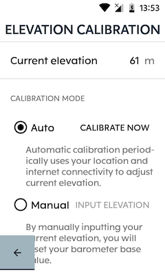
But when I look at Elevation Calibration, the Current elevation is given as 61 m (which is absolutely spot on for my current location).
What's also confusing about this is the use of two different terms for what is essentially the same thing in the context of the Karoo 2.
Altitude is the vertical distance between a reference datum (usually Mean Sea Level) and an object (in this case, the Karoo 2).
Elevation is the height above a fixed reference point or geoid which, I'm assuming, should be the Karoo 2's height above mean sea level (MSL).
When the altitude is greater than the elevation, this suggests that the Karoo 2 is using an object below the mean sea level as a reference datum! Some consistency in terminology would be welcomed here.
I understand the Karoo 2 uses an internal barometer to measure vertical distance. Presumably, it is capable of automatically setting the QNH - based on the current location - which is how it arrives at the Current elevation?
-
Official comment

Hey Steve,
Thanks for posting this here & thanks @Michael for chiming in :)
Altitude is calculated based on the GPS fix of the location, This can vary based on the geography of the location and the accuracy will vary if there is tree cover, canyons, etc. The Current elevation is calculated via the internal barometer on the Karoo 2. If you would also notice that altitude value would constantly fluctuate as the GPS signal is constantly updating the positional fix to be more accurate, at certain times this can number can inflate. The Karoo 2 uses the current elevation value to display your data on the elevation graphs and also to chart out the upcoming elevation as well :)
I can totally understand how confusing it can be to see two different numbers on the karoo, We have made a note of this as we shall ensure to clear out the confusion here. You can continue to rely on the current elevation that is shown under elevation calibration :)
We do ensure that the data represented on the Karoo is as accurate as possible but it is a universal fact that elevation gain calculations are quite hard to arrive at due to various factors such as GPS data, Barometric data changes due to pressure fluctuations, etc.
Here is an article that can give you more insight s on this: Calculating elevation gain
Comment actions -

The altitude reported in the GPS screen is probably determined using GPS data (as it's located in the GPS menu). This is a method resulting in a very rough estimation of the altitude.
The current elevation is (as is indicated) being determined using your internet connection. Probably by using map data.
-
Not sure, but the Current elevation value appears to be highly accurate. I can see this value decrease by ~2-3 m when I go down one flight of stairs and increase by a similar value when I go up one flight of stairs.
Also, I completed a ride over the weekend and the recorded elevation profile appeared to be accurate to within ~10 m of Strava's data.
I've sideloaded a GPS app on my Karoo 2 but this only reports on the altitude above sea level, based on a radar survey matched to my GPS location.
I'm just not sure where the GPS sensor altitude is coming from, but it appears to be an incorrect value.
-

Built-in GPS altitude is still not correct (in my case about 50 meters higher than current elevation in elevation calibration menu). Total Elevation gain according to Karoo2 is higher that GPS measurement with another device (ie Pioneer Powermeter). In Dashboard (Ride) i see a +482 m Gain (??!), Ride with Pioneer 111m, Ride with Karoo2 145m. It find it very confusing.
-
I agree that total elevation gain on the Karoo 2 is invariably incorrect. What's strange about this, though, is that I have analysed some of my rides and compared heights recorded on the K2 against spot heights taken from an Ordnance Survey map and the values recorded on the K2 are pretty much bang on.
It's when the total elevation gain is calculated that the problems start. It seems the calculation for total elevation gain is way off.
Admittedly, I don't live in a very hilly area and 150 m is about as high I can go around here. That said, whenever I reach the top of a climb, I always make a note of the elevation recorded on the K2 and compare it with the spot heights published in my OS map. Almost always accurate to the metre.
Luigi, one thing I found is that I had to manually calibrate the elevation before the auto calibrate worked for me. It's really strange how this behaves but, immediately after performing a factory reset, it was displaying my elevation as 88 m. My current elevation is 60 m. I manually calibrated my elevation using the 60 m value. I then set the K2 to auto and the 88 m value changed to 60 m! Very strange behaviour!
-
 It appears to me that the Karoo 2 has an elevation database on board that is used to make the auto calibration. It says that it's done through the internet but I find it calibrates accurately when turned on without an internet connection.
The altitude value showing in Built-In-GPS comes from the 3d position fix that is calculated based on the distance from multiple satellites. The optimum satellites for fixing elevation can't be used because they are below the horizon and thus the GPS elevation is not all that accurate. I don't believe that the K2 uses this elevation value for anything since it has the database and that is more accurate.
Please sign in to leave a comment.
Comments
6 comments