Elevation clash of Dashboard vs. K2 vs. Komoot/OA...Or simply misleading/useless information of Dashboard?K2 sensor?...
Answered
Hi There,
first of all I love my K2 and already convinced 2 friends of mine to dust their 1030! You only need to get those units produced...
I will post my questions and also feature request within the next couple of days/weeks, because I have spotted a couple of things which may make K2 even better than it already is!...
Now back to topic:
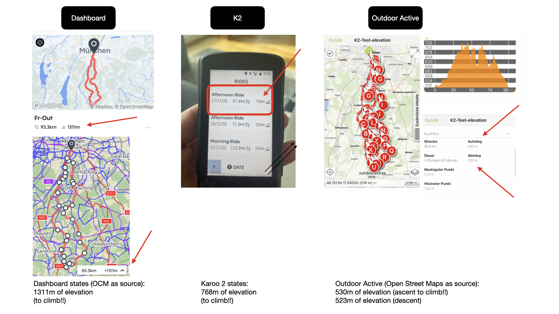
I have a couple of questions about the elevation in the Dashboard and hope to get some answers as I think that there must be a bug or similar... To make it easier to understand I attached a quick comparison:
- What is the elevation figure (1311m) stating?? Is it ascent? Or is it total elevation (ascent+descent)?
Comment: If it is total elevation then this figures i totally useless! I will then never have the chance to make a proper route planning lets say to make a 5 days trip in the mountains where I sleep in a different town each night e.g. crossing the alps from Munich to Italy... Why? If it is total elevation (ascent+descent) only then I will never know how many meters I have to ascent and descent on each of the different days as my start and end point will be somewhere 80-120km far away! And ascent and descent are not equalising each other.
Improvement: If the 1311 in this case is the total evelvation (ascent and descent) then please show descent and ascent separately from each other! - Is K2 showing 768m of ascent? or is this total elevation (ascent + decent)?
- Whats wrong with the accuracy? If the Dashboard shows 1311m and it would be ascent only, then something is terribly wrong with the dashboard. 1311m vs. 768m vs. 530m.
- Whats wrong with the accuracy? If the Dashboard shows 1311m and its total elevation (ascent+descent) then its still difficult to understand or something is wrong in either the Dashboard, K2 or the hiking app. 1311m vs. 768m vs. 1053m (530+523)
- How accurate is the measurement of the K2?? It has a barometric sensors as far as I understand. Its calibrated and shows the correct altitude. But there is still a significant gap between the hiking app and the K2 figure assuming it is 768m (ascent) vs. 530m
- Can you please add a ascent and descent figure in the K2 unit as well as in the Dashboard, same statement as above for the Dashboard applies.
I am happy to receive some answers on my post.
All the best and many thanks
Andi
-

Hi Andi, I will be happy to answer your queries.
The elevation estimate you see on the dashboard while creating a route will not be the exact same result on the ride. The elevation estimate on the Dashboard is based on the BaseMap. The elevation gain you see on your Karoo is based on the actual GPS points of the ride. This is the most accurate data in relation to your ride.
As per the current implementation, the elevation value does change with the change in atmospheric pressure on the Karoo. We need to refine this, although the location also takes part in the initial elevation fix. So, we need to correlate the value between the atmospheric pressure and the location.
The difference of +/- 100 meters, which is considered okay as the Karoo records using the Barometer in the device. The Barometer works based on the atmospheric pressure in the air to compute your elevation. The elevation recorded this way may be affected by weather as pressure varies throughout the day.
On the Karoo, you have the option to add the Accent and decent data filed.
https://support.hammerhead.io/hc/en-us/articles/360008478974-Data-Fields-LegendWe will be improving or updating the dashboard in the future with fine refinements. You do have an option to check the Elevation gain and loss on the Dashboard. I have attached the screenshot for your reference.
For now, we recommend you to create a route on the dashboard and try checking the elevation on Strava before taking a long ride since that seems to be a very important stat for your choice of rides.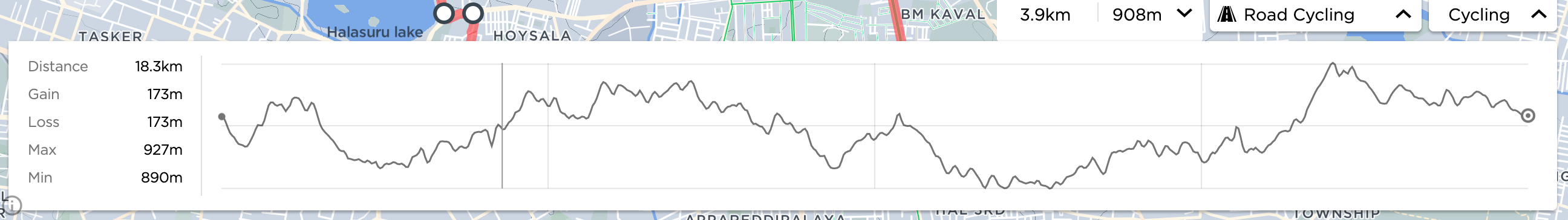
Please sign in to leave a comment.
Comments
1 comment