Elevation gain totally wrong

Hi there,
I know this topic was adressed several times before but it was obviously not fixed until now.
The elevation gain numbers my Karoo 2 device gives out after each ride have been inaccurate ever since and I had to correct them via Strava. This has been a big disturbance but I was waiting patiently for a fix. And sometimes the numbers were not too bad.
But since a few weeks (can't really tell a concrete date) the numbers are just rubbish. Please see my 2 examples below:

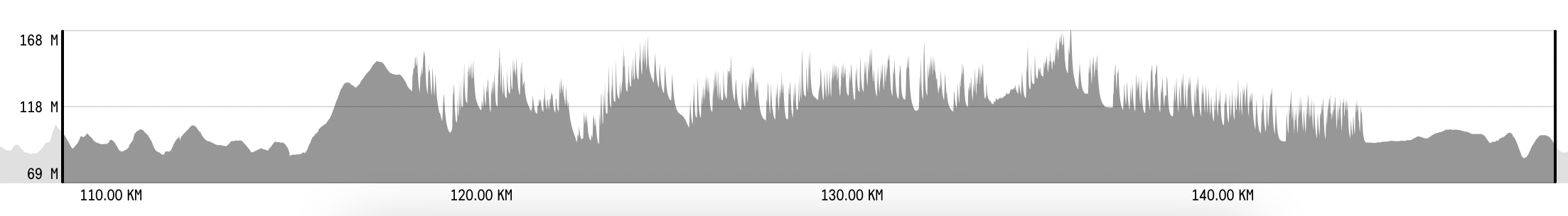
This is a ride from today in Hammerhead Dashboard. It says the total elevation gain was 1348 meters !
In Strava I used the function to correct elevation gain and I got this (which is definitely closer to the truth!):

It calculated 261 meters. That's nearly 1000 meters difference! Totally inacceptable!
And if you look closely to the graphs, you can see that they match. So the device seems to measure correctly when there is a climb or even just a short elevation.
But what you can also see, when you closely to the graph from Hammerhead Dashboard is, that there are short spikes all over. As far as I can see, they occur mostly when descending.
Maybe that's part of the problem? Can somebody confirm that?
Find out where those spikes come from and eliminate them. I think we will have way better numbers then.
I have loads of examples like that. all with the same observation.
-

I have the same problem. Reaction from HH support same as described.
Elevation on route on Komoot and Strava 262m, whilst the ride showed 414 meters. Ik ride in belgium, and I wonder if this has to do with an error in the map. I saw that the Climber function also shows wrong altitudes. The elevation gains in percent looked reasonable, but the elevation left to the top was equally overestimated. For upcoming climbs, this error cannot be due to the barometric device, but must be in the algorithm, or errors in the map.
Any ideas?
-

Another element of the mystery: last week I rode in France (near the Tour de France route) instead of Belgium as usual. And the elevation was correct! Slightly more than Strava measurement but very close (30m difference over a 1800m ride for example). I even thought they had solved it.
And I went back to Belgium and did a gravel ride, elevation was all over the place (800m instead of 300)…
It seems vibrations have an impact, position of the device on the bike (horizontal is better). But also localisation? This is weird. But it seems a lot of people in this thread are localized in Belgium or the Netherlands… -

Hello there ! just bought the HH karoo2 . Same problem as described for me and my friend , i have also notice that in the calibration page my altitude was 17 meters and when i was shaking the device it was changing all the time 22 25 11 13 20 . So if its happening in a riding scenario no wonder its register way to much elevation gain . If they cant fix this issue at least they should give the option of Altitude Via GPS data instead of barometric it sound easy to do i my head ahah .
-

Hello, I m French and I bought too K2. I am very disappointed by this problem of data on the elevations. while reading the posts on this problem, I also did some tests. the latest and drive 40km without following a trace, with manual calibration at the start, and without SIM card installed. the final data is 10% consistent. (385 on K2, 353 on strava with elevation correction, and 351 on Sporttracks by importing it directly via a Fit file. when I create a route on the HH application, the elevation data is quite correct, I I have the impression that as soon as you activate the GPS to follow a created route, the problem appears. It's really problematic because all the functions associated with tracking the elevation are not usable. It's a serious problem which harms the development of the brand in Europe, because other brands are more reliable
-

As I have written, I don’t ordinarily have this problem with my Karoo in Finland (while in Germany it goes completely nuts), but there seems to be at least this one stretch (~25 km) of road (route 438 between Virmutjoki and Lohilahti if you want to send and investigative team there (no I didn’t think so, it’s a nice road but not much to see except for trees and the odd little lake)) where this happens (n=2, last month and the same thing also a year ago) whereas the before and after looks quite normal:
Curiouser and curiouser. (And no, it had definitely nothing to do with bumpiness, because this road was pretty smooth by local standards and the by far roughest section of the ride (12 km of loose gravel) earlier looked completely normal.)
-

vibrations, SIMs, etc.... it's a real problem!
The strange thing is that it is not something that happens to all units and to the same extent. When I go out with my wife's Karoo2 on my same bike it reads perfect, on mine it reads approximately double that. With a friend Karoo2 results are x4
No solution?
Many users have changed the unit and the 3rd one has been the good one. It is a factory defect and they should fix it. How garmin solved its blue Halo for example.
-

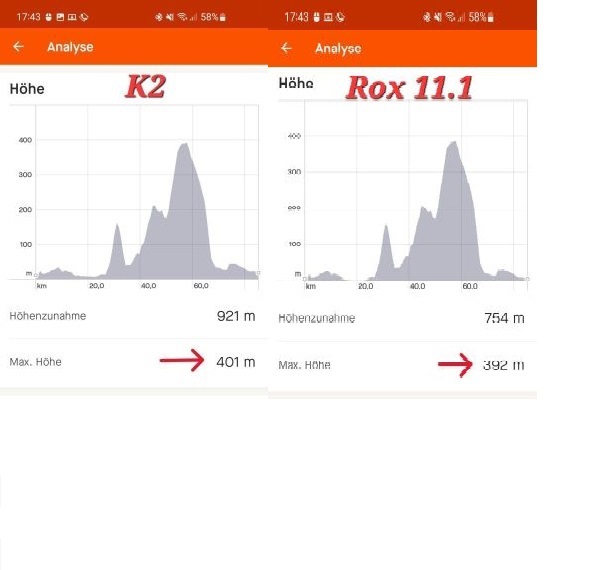
Mein K2 scheint auch ein Höhenproblem zu haben. Allerdings ist es nicht so schlimm wie bei vielen Usern hier.
Ich habe ca. 25 % Abweichung zwischen Sigma Rox 11.1 evo und K2.
Also zB 149 m statt 110 m oder 843 m statt 630 m und es ist nervig jedes mal die Strava Höhenkorrektur anzuwenden.
Keine Ahnung, was da schief läuft, aber die Höhe scheint er richtig zu zeigen.
Sollte ich ein Ersatzgerät einfordern???
-

My K2 has been mostly ok, even with the SIM in the elevation is roughly ok, mostly a bit bloated.
After a recent gravel trip through the actual Karoo (Prince Albert, Western Cape), the K2 stopped recording altitude, temperature, grade, now displays "no sensor".
Ive removed the SIM card, factory reset, still wont work.
-

Hello,
I have Karoo 2 for almost a year now, I'm happy with the device. Of course, like many others, I also noticed that the elevation calculation is not the same as, for example, Komoot.
A short note, I am a hobby rider (racing bike) and elevation recording is not that important to me - a few percent up or down is not the end of the world for me :-), further every ride I records using both Komoot on my mobile phone and on Karoo 2.
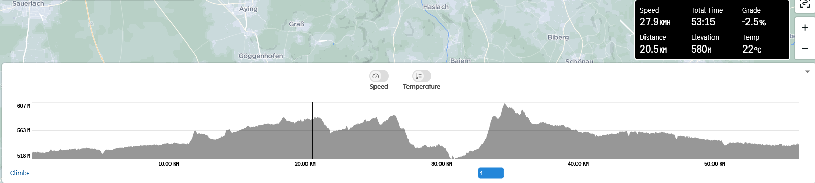
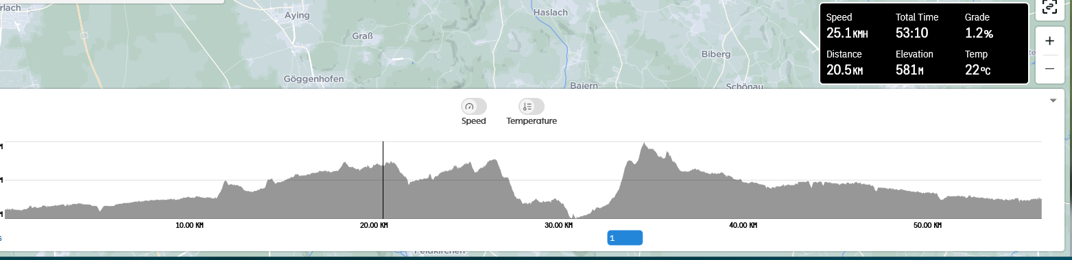
However, when I compared the elevation graph on Komoot and HH, Karoo 2 has the same altitude measurement accuracy as Komoot (the difference is statistically insignificant). For example, at a distance of 20.6km, Komoot measured 579hm, and HH measured 580hm.
I compared a lot of points on the route, altitude measurement by Komoot and HH, the difference is minimal or none.
See attached graphs.
!!! BUT !!!
HH on multiple points has measured two altitudes which sometimes differ !
Example at the distance of 20.5km, once HH recorded altitude of 580hm and second time recorded 581hm.
First, I thought HH is making duplicate recordings, but looking at other details (Total time) they are not.
Recording with altitude of 581hm was made at time 53:10 and second recording with altitude of 580hm at 53:15 (5 seconds later).
Komoot on the other hand, records on a minute interval and on the same point (20.5km) recorded an altitude of 579hm.
So, right, it might be that HH recording frequency is higher the other e.g. Komoot which then might lead to the differences in total Ascent/Descent calculation.
Also notice differences in "Grade" measuring, on the same spot once is at 53:10 time grade of 1.2% and 5 seconds later at 53:15 time grade was -2.5%. Assuming speed of 30km/h, traveled distance for 5sec would be then ~42m, so it could be possible the measurement reflects proper elevation profile within that 42m distance - I personally don't recall what was the road profile at that place.
So, somehow, I think that altitude measuring done by HH is generally correct and done at higher frequency then others (e.g. Komoot) which might explain differences.
Not sure also how total Altitude/Descent calculation is done and what role plays "Grade" in HH calculation algorithm for total elevation numbers.
HTH
Goran
-

Hi, It's great to hear that some folks are getting reliable data from their devices. So, I decided to check out my own data and see how it stacks up against what you've described. I looked at my five most recent rides to compare.
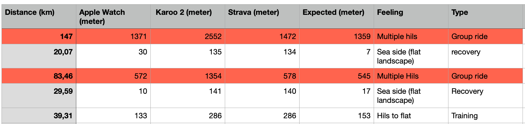
I found that for some rides, the data seemed about right, although it was sometimes off. These were usually easy-going recovery rides on smooth roads. But when it came to the more important group rides, the data was way off, and not just by a little bit. It was so far off that it didn't really help me during the ride at all. In one case, I hit my total elevation before I was even halfway through my route, making the data pretty much useless.
This got me thinking, so I decided to check out the data from when I was riding in the French Alps last year. Surprisingly, it was pretty accurate, only a bit off, but nothing to worry about. Even though I was going slower during those climbs compared to the hills shown in the data, on roads that were much smoother than the cobblestones here in Belgium.
So, my takeaway from all this is that the faster I ride on a less-than-perfect route, the more inaccurate my data becomes.
Now I'm not sure. Are most of you getting results similar to mine, or are you mostly bothered by small differences, like the one mentioned in the previous post?
-

I have responded and posted numerous times about this issue.
I have concluded that vibrations cause the inaccuracies... I did this by using 2 Karoos...one on my handlebars and one in my rear pocket...and every time the unit on my handlebars gave way more total elevation...up to 30% more. The one in my rear pocket corresponded to my Apple watch and to the corrected Strava values.
Also depending on the bike and terrain the elevation is way more on my rigid gravel bike with lots of vibration...on my MTB it is only about 10% more...pretty conclusive I woud say and I do not see a fix coming.
I have been in touch with Hammerhead, they have analized my .fit files and seen the jagged elevation profiles...but no conclusion a year later.
Surely a smoothing algorithm will work??
-

@Matthias
Same for me. 🙈Shows the correct height if I load a route but the recorded data differs by a lot. Sometimes more, sometimes less on the route I take.
Problem exists since I have the device and no fix in sight. The support told me once via mail that I should use the adjust elevation feature of Strava. So I use my Karroo nowadays for showing data of the ride (while doing the ride) and record it as a backup but I upload the ride to Strava via my Garmin watch, which is pretty accurate. 😅 -
First, on your device, it should be determined whether the problem is in the barometer for measuring altitude or in the SW or eventually in both.
The simplest way, in my opinion, is to do a test ride that will be recorded on HH and on a mobile phone using e.g. Komoot.After that, you should compare the elevation graph points recorded on HH and on Komoot - the more points, the better. Of course, calibration of HH should be done beforehand.
If there is a significant deviation at a large number of elevation points, e.g. HH recorded an altitude of 500m and Komoot 250m, then there is certainly a problem in HW ie. barometer and/or even a SW (algorithm for calculating altitude).
If the deviations are minimal or absent, then the HH device determines/calculate altitude well and the problem probably is not in the HW.Here is a short excerpt from Wahoo on how they devices determine current altitude:
When a ride starts, the ELEMNT, BOLT, and ROAM calculates elevation using the barometric altimeter and compares it to the reported GPS elevation. If a discrepancy is found with the barometric altimeter elevation, the ELEMNT, BOLT, and ROAM adjusts using GPS data. Before this is done however, the ELEMNT, BOLT, and ROAM performs additional calculations to determine GPS elevation accuracy. If GPS elevation is deemed inaccurate, it is discarded and no adjustment is made. This prevents skewing elevation data with poor GPS data, but also means that certain situations may also prevent the ELEMNT, BOLT, and ROAM from correcting barometric altimeter drift with GPS.
-

I don’t understand why there isn’t some smoothing that can be applied to fix this. What is the resolution of the sensor? Can’t they just eliminate the recording if the sensor records up and down movement of a few inches? Elevation issues is the only thing the Ali/HH doesn’t respond to in this forum despite years that this has been mentioned.
-

For me, it use to show correct elevtation gain, but now for a couple of months its incorrect. It shows way too much then is should! So its more a software issue then a hardware. But would be good to hear from the devs, what's actually wrong! If this is not fixed, I will say good bye to Karoo for good! I don't things like that not being fixed, which are essential.


Please sign in to leave a comment.
Comments
116 comments