Incorrect Elevation Gain
Answered
Hi guys,
Let me share with you a couple of bugs I have found:
1. When sync routes from Komoot
Planned route in Komoot:

Dashboard after sync Komoot account:

Can't understand the difference !! And why does it change from 370 m (which is the real gain) to 728 m!
2. When riding
Planned route in Komoot:

Recorded route in Karoo:

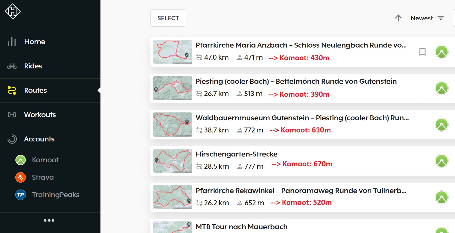
I truly believe that Komoot has calculated the gain correctly, but these 500m difference it is simply not possible....But there's more... When you click on the route, the gain is different...

Can't send now the K2 screen but at the end of the ride the field ASCENT showed: 1772 m. I'm gonna try switching the Elevation Calibration to Manual to see if this second problem is solved, but the planned routes one (where apparently the dashboard just has to sync with Komoot) I can't figure it out.
Thank you !!
-

I've compared spot heights on an Ordnance Survey map against elevation points on my rides and my Karoo 2 is almost invariably within a metre or so of the OS spot heights.
It's only when the Karoo 2 starts aggregating elevation and putting it on the Hammerhead Dashboard that things start to go wrong.
Ignore elevation data on the HH Dashboard; it's junk.
I've just tried correcting the elevation in two of my rides on Strava and on both occasions, the elevation has actually increased by a few metres (on a ride of approximately 550 m elevation gain).
Ultimately, the only definitive source of truth for accurate elevation data is a properly calibrated GPS or a good old fashioned Ordnance Survey map (if you're in the UK). Cycle computers are all inherently as inaccurate as each other and, in my experience, route planning applications like Komoot and RidewithGPS are also wildly optimistic (or pessimistic). Strava just seems to crowdsource elevation data from multiple cycle computer recordings of rides on that route and calculate elevation based on an average of that data.
-

Of course it is correct.. and the uploaded routes in Strava and Komoot are also correct. But when you are choosing a route on the the fly with the K2, then it would be nice, if the data would be correct and you wouldn't need to open Komoot again... Its just ridiculous, that this cannot be solved within months...
-

FIXED IT!!
I have had every ride with wrong elevation and had to use strava to correct it, after reading a post that Steve posted
1 ) I did a factory reset ...... PS you don't lose any profiles when you sync it with dashboard it all reloads.
2) Connect to Wi-Fi and pair Phone ,Check updates and Download Map
3) Go to https://whatismyelevation.com/ and make a note of that
4) Manually input elevation no matter what the Auto calibrate is.
5) Restart K2
This worked for me so good luck if this helps.
-
I'm glad my post helped you with this, Colin.
Auto Calibration definitely seems to have some issues; I have raised this with HH previously.
Just as a general observation, there is a perception that Strava data is 100% accurate. I don't believe Strava data is 100% accurate (because it's a crowdsourced average from other cycle computers which are all as bad as each other at reporting elevation data) so it's probably best that we stop comparing our Karoo 2 elevation data with Strava elevation data and complaining to HH when it's a few metres out. Same goes for Komoot and RwGPS. The only definitive source of truth - if you're in the UK - are the spot heights and contour lines on an OS map of the area.
-
Hi Steve
The one thing I noticed was the K2 Auto elevation at home was 236ft and the https://whatismyelevation.com/ gave me 119ft, I took the K2 to work, I then looked at https://whatismyelevation.com/ 168ft and the K2 167ft fingers crossed it keeps working.
-

Well, it is not about Strava being 100% accurate. And it is not being a few metres apart from Strava. It is about HH being 25-45% off. If you create or import a route, the HH Dashboard calculates the total elevation always way too much. Mostly about 30-35%.
So this is not about Strava, not about a few metres. And nót about calibration of the unit itself. That is another issue, what can be solved maybe in the procedure described above.
The problem of calculation of elevation in the HH Dashboard is a basic problem that HH should solve IMHO. It is a basic feature for a cycle computer, and especially for a sophisticated one like HH Karoo. (Even more so, beceause HH Karoo is highly marketed as a Cycle computer with outstanding routing and navigating capabilities).
Hammerhead people: Agree, disagree? Please chime in….
-
Like you said I don't take anyone of them 100% and its not about a small amount.
The HH Create a route is wrong as well as the Auto Elevation on the test I did today that's my finding so don't shot me if you find it's not the same for you.
HH Dashboard route = 774ft
K2 Auto Elevation on = 790ft
Strava = 519ft
Komoot = 483ft
K2 after reset and Manually input elevation = 521ft
I have had lots of bike computers in my time the K2 is the best I've every had love it.
-

The fact that we're on this support page means there definitely is an issue. And the K2 is also the better computer unit I have owned, but it's also the least accurate of the lot. I've tried the tips and advice offered here - it's better, but the ascent is still out by 10-35% with each ride. Honestly, I expected HH support to have fixed this by now.
-
Indeed. And to be absolutely clear: It is not (only) about what Karoo tracks as elevation gain during a ride. But also what Hammerhead calculates as elevation gain for a created route. (Even a route that is synced from eg. Strava routes gets an elevation gain that is way out there.)
But also there is this problem that the climb function acts weird: On a regular climb with let's say an grade of 5% it wil show 5%, 19%, -3%, 5% etc....
Same with Strava segments: The graph shows you something that looks like a huge ride in the mountains, even if it is flat as can be in real life.Are these issues related technically? I don't know. But the thing is: They are not solved with a reset/calibration etc. of the unit itself. (Maybe only the elevation it shows for the place you are at the moment) But the problem is how HH handles elevation in general.
And don't start with: Yeah, but every map or every computer is somewhat off. I know. No problem. But it is a problem when HH is of by 50% where all the others are within 5%.....
So Hammerhead staff: Please respond to this and don't let us in the dark forever. At least tell us if you cannot fix it.Thanks.
Benno van der Velde -

@Benno Let me respond to you ONLY in regards of Strava segments:
"Segments are always created from a Strava activity and as a result, they inherit some of that activity's characteristics. If the original activity was recorded by a GPS device with a barometric altimeter, the segment will use the barometric data recorded by that device."
https://support.strava.com/hc/en-us/articles/216919447-Elevation-for-Your-Activity
-
Hi Martin,
Thanks for your answer. But Strava segments is not really the problem here. If The Karoo would copy the elevation data from Strava routes and segments there would not be a problem. But the problem is about how the Karoo handles/determines elevation data. For new created routes, for synced routes, for Strava segments, for their own Climb app etc. etc.....
-
Just an update after reset and manually putting in my elevation
I have done 4 rides and all have been within a small difference of what strava gives you so happy with that HH route plotter is wrong on all of them rides but we know that so only plotting route on other platforms but would be nice to use HH Dashboard
So for my K2 it was the Auto Elevation which gets it wrong so something wrong there too. -
Yeah, the distance and elevation data on the HH Dashboard is junk and I'm pretty sure HH must know that by now.
Best to just ignore that and use an alternative service (Komoot/RwGPS/Strava/etc...) for planning and analysing rides.
Be aware, though, that the distance and elevation data on those services may also be inaccurate (I've found elevation in RwGPS rides to be way off).
-

Elevation and slope errors. Turn on unit and check current elevation. Elevation increases 40 feet while sitting in my garage. Riding up a steady climb, grade will vary from -17% to +23%. Tried resetting elevation manually, automatically., and reset unit to factory default. Same issues.
-

That sounds very much like poor GPS signal or GPS data corruption. Does staying stationary in clear sky view (no foliage, buildings, sources of strong radio signals from any number of sources) have any impact on the elevation display compared to inside your garage or moving uphill/downhill? Just a gut feeling based on 30+ years of radio communications servicing/troubleshooting during my career but one way or another 90% of the problems reported across the board seem like they are RF-related as the root cause, keeping in mind the everything from GPS to ANT+ to BLE are at the end of the day are all very, very low signal level RF-based applications of data transmission on heavily shared frequencies. It makes me wonder sometimes if the internals of the K2 might even be it's own worst enemy as a source of low-level RF radiation or poor shielding let alone the bombardment of dozens of high and low power external sources as we move about. For years now I have had a pair of high-end BLE earbuds paired to my phone, the two devices not half a metre apart as I ride. I know they will go silent at exactly the same spot on the same road every time, a dropout of 15-20 seconds as a I ride beside a heavily populated residential area..That's not the earbuds causing it when it's 100% repeatable, that's external RFI overwhelming the signal between the phone and the earbuds. I have absolutely no doubt that these cycling devices suffer from the same problems that are quite common with consumer-grade electronics in continually changing RF-saturated environments while we move about through different locations. Ok, off my soapbox.
-

Just received my Karoo 2 yesterday, having previously used a Wahoo Elemnt Bolt. I was surprised that the elevation gain on my K2 and on Strava wildly varies, showing about 50m of ascent for a route which I know has max 9m. Looking at the elevation profile, on a relatively flat section, this fluctuates up and down as if it was a pump track. The GPS route data is also fairly squiggly when comparing my route to the road layout. Proper elevation recording is essential to my use of the K2, it would be good to understand how this is being managed by Hammerhead.
-
I'm afraid this problem is around for a long time already. For me it started to become a bit better last couple of weeks. I live in Amsterdam, The Netherlands.
So I don't know what is happening. Not very much official announcements or info from Hammerhead on this case. It is frustrating as H.... I mean: This is a basic thing to have in a cycling computer: A map and elevation, climb profiles etc. who are correct..So I hope they prove me wrong, but don't expect it to be solved in the near future.
-

I reported the same problem via this forum and was waiting for month w/o any progress. Finally, once Hammerhead started to actively promote the new climber function (which was absolute unusable in my region due to this bug) I got sick off waiting and started to play hardball. I opened a support ticket indicating that this is a major product fault and asking for a definitive fix date until I can start to use my K2 as it is supposed to be use.
As the support wasn't able/willing to give me any fix date I requested to return my K2 and get a full refund for my purchase with the argument this is major product bug. They accepted this request and I returned my device and got full refund.
I'm using now a Garmin 1030plus ... which works perfect. Ok ... handling of the K2 is better then Garmin but functionality is same/better, visibility of new display is great, akku life is absolute great and I've no more connection problems (which I always had with my phone and powermeter with the K2).
So folks - it's up to you ... either return your devices to increase pressure to get this fix or continue waiting (I was waiting 8 month) ... -

@Ken Neth you may have a dodgy unit, mine records elevation spot on and has done for a long time, this is inline with the overall feedback from the rest of the community.
My friends K2 recorded extremely high elevation and the unit was replaced by HH, the replacement unit was fine, so more hardware related than software.
-
Recording elevation is one thing. Showing the right elevation in climber, or on Strava Live segments or on routes imported from eg Strava, Komoot, etc is another thing.
That is where the Karoo is almost never correct. And that is NOT acceptable from a high end cycling computer highly marketed as a standout in maps, routing, navigation etc….
-
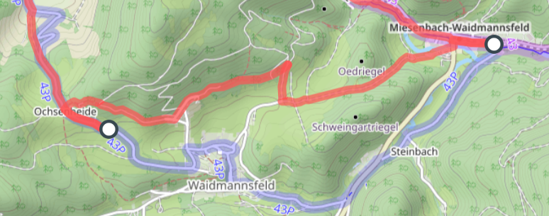
@Paul: I might be wrong but.....looking at the second route thumbnail, specifically on that super-straigh line at the bottom. It seems to me as if you imported the route from Komoot but since HH using different maps, so it might have not projected onto the HH's maps correctly and it's not aligned.
Did you examine the route on HH if it follows properly the actual tracks/paths/roads?
Did you try to edit the route in HH dashboard, and move one of the waypoints a lil bit so it recalculates the route.




Please sign in to leave a comment.
Comments
84 comments