Navigation - Route Profile with POIs

Hi all,
Congrats for considering user feedback and improving so fast.
I think a great feature would be a data graphic field with the entire profile of the route. This helps while racing to see the current position in the elevation profile.
If users add distance to next POIs, like hydration points, helps to manage nutrition and effort while racing.
Thanks and keep on rocking!!
-

Hi Diego,
You can add the upcoming elevation data field as a visual data field on your map page. You need to select the correct data page layout and this should be possible. We have another data field that shows you a visual representation of Elevation + Distance remaining. Would love to hear your feedback if these solve what you are looking for.
We also recently added the ability to see upcoming POI's in the turn-by-turn drawer. You can find more details here https://support.hammerhead.io/hc/en-us/articles/25642819120795-Karoo-OS-Turn-by-Turn-Directions
If these solutions do not solve your problem, can you please provide more details of your use case so we can better understand what you need in the future. Thanks!
-

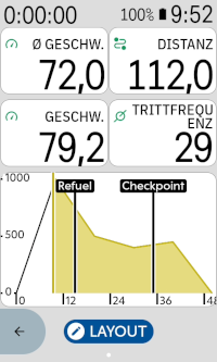
I am also interested in this feature, i. e. an elevation profile that shows the complete route profile and includes POIs, so I prototyped an extension for it.
I'd like to also include climber segments in the graph, but that is not supported by the extensions sdk (yet). On my previous headunit, zooming out the elevation profile always showed the whole route with the colored climbs, and I'd like to have that on the Karoo as well (+ the POIs). I used it quite a lot to get an overview over where I am on long routes.
-

@Product Team: Unfortunately, the graphic field showing the elevation profile only renders the next couple of kilometers on the route, while the graphic field that combines elevation and distance remaining only shows a bar (which is better than nothing).
As @timklge described and prototyped, I would also be very much interested in either a graphic field with the elevation profile of the whole route, or a graphic field showing where I am on the route on an overview map.
As to the reasons why: I find it motivating on very long routes (>100km) to be able to tell visually how much of the route is left or where I am on an overview map. -
Hi all,
Thanks for the feedback here. Some really cool ideas we can definitely explore in the future.
I know this is still not exactly what you want, but just a pro tip that you can zoom in and out of the 'Upcoming Elevation' graph data field by tapping on it. This way you can change "how much" of the route is visible at any given time and it does also indicate your current position.
We can definitely explore adding more to it in the future regarding your ideas about adding POI's and grade to the chart.
-
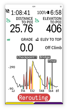
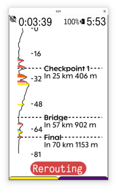
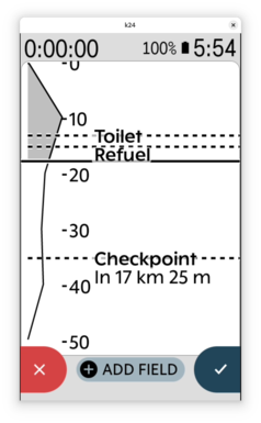
I've continued tinkering on an extension that provides this feature until it is eventually added by Hammerhead natively. In addition to having an elevation profile that includes climbs and POIs, I also like the idea of having a full-height flipped elevation profile data field that you can add as a data page to better use the screen for long routes.
I'll use it during some longer rides this season and post it over at the extension forum when it's ready
-
Thanks! It's a functional screen of an extension I have built using Hammerhead's SDK. The SDK allows extensions to access the currently loaded route and the list of route-specific and global POIs. So it's possible to calculate the closest points on the route to the POIs and build a datafield that shows them.
Unfortunately, as of now, the SDK does not expose the elevation profile of the current route, so the extension downloads the elevation data for the current route from an external API. I use https://valhalla.openstreetmap.de/, hosted by german non-profit FOSSGIS organization. This works, but is obviously not ideal, because it requires an active internet connection on the Karoo (e. g. via the companion app); I hope Hammerhead will add support for extensions to read the elevation profile in a future version of the SDK so no external service is required. The SDK also does not provide access to the detected climbs on the route, so I calculate them using a simple algorithm that works well enough, but will not perfectly align with the climbs identified by the Karoo.
-
@Product Team: Great, thanks!
@Diego Dursi: I think showing info about the climbs in addition to the POIs is a great idea. Maybe climb and climb length would be the most useful instead of VAM and ETA to summit?
Unfortunately, if you have a lot of short climbs on the route, it quickly gets cramped. You can change it to smaller intervals just like the native elevation profile though by tapping on it, and then there's more space. Currently I've set it to toggle between the upcoming 2 km, 20 km, 50 km, 100 km and then the whole route regardless of where you are on it (which is the default).
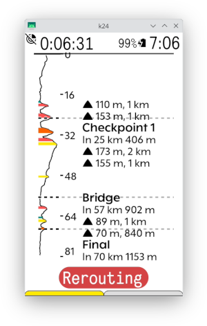
-
I have pushed my initial build to https://github.com/timklge/karoo-routegraph . I have used it successfully during some rides and I think it fulfills its main purpose of providing an overview of the route with upcoming climbs and POIs, but there's a lot of room for improvement.
- Because karoo extensions can currently not access the route elevation data directly, once you load a route, the extension will attempt to fetch the elevation profile from the Valhalla API hosted by FOSSGIS e. V. Your karoo thus needs an active internet connection.
- Because karoo extensions can currently not access the climb segments identified by the Karoo, the extension will try to identify climbs using an alternate algorithm, so they will not perfectly match up with the Karoo Climber feature.
- "Show gradient indicators on the map" feature is not available yet.
- No customization of what climbs are displayed etc is available yet
If you try it, let me know if it works for you.
-
Thanks. Yes, a native integration is always preferable to an extension, but I don't know where this is on Hammerhead's roadmap. If hammerhead adds elevation profile and climb access to the SDK so the extension does not need to download the elevation data from an external provider, I think the user experience of the extension version can get close to the quality of a native implementation.
-

@product team
I know this is still not exactly what you want, but just a pro tip that you can zoom in and out of the 'Upcoming Elevation' graph data field by tapping on it. This way you can change "how much" of the route is visible at any given time and it does also indicate your current position.
Did this break in the latest version? I used to be able to tap and double tap on the graph but now it brings up the data field switcher functionality instead.


Please sign in to leave a comment.
Comments
25 comments